Active filter
- Search for "Western"
- Sort by "Best results"

Ettringer Bellerberg - Vulkanparkstation
Ettringen
The Bellerberg volcano was created 200,000 years ago, a cinder cone typical of the Eastern Eifel. The "Ettringer Bellerberg" and the "Kottenheimer Büden" form the western and eastern flanks of the large Bellerberg volcano. From the summit of the "Ettringer Bellerberg" you have a fantastic view of the surrounding volcanic Eastern Eifel…
More information
Ortsgemeinde Lind
Lind
The local community Lind with about 50 inhabitants is located in the western part of the association community Vordereifel at an altitude of 470 m above sea level, in close proximity to the districts of Vulkaneifel and Ahrweiler. The Josefskapelle, located in the center of the village, was built in 1858 on the ruins of an older chapel…
More information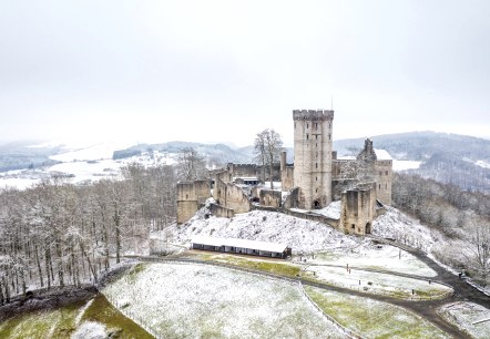
Kasselburg Eagle and Wolf Park
Kasselburg Castle towers high above the Kyll river in the Eifel on a vertical massif of dolomite rock and basalt. The well-preserved ruins are home to the Kasselburg Eagle and Wolf Park with its many majestic birds of prey and the largest pack of semi-wild wolves in Western Europe…
More information
Aussichtsplattform "Silbersandblick" am Hochsimmer
St. Johann
The viewing platform "Silbersandblick" is located on the western flank of the Hochsimmer near the hiking trail up to the Hochsimmerturm. The 26 m² wooden platform is equipped with 2 large benches and was created in summer 2020 by Josef Ackermann in cooperation with the forest and officially handed over to the local community of St…
More information
Ettringer Lay - Vulkanparkstation
Ettringen
About 150 years ago in the " Ettringer Lay " ( Lay= stone quarry ) the deepest stone beeches around the Bellerberg volcano were formed. Not without danger the mighty stone columns of its western lava flow were broken here in order to extract building material or paving stones from it…
More information
Ortsgemeinde Ditscheid
Ditscheid
On the western edge of the municipality of Vordereifel lies the small village of Ditscheid. From its local mountain, the Steinbüchel, you can enjoy the view over the village and a beautiful landscape. The Steinbüchel Landscape Park invites the 265 inhabitants as well as guests for a relaxing stay, as well as the "XXL-Baumelbank" located not far from the sports field…
More information
Oct 14, 2025 Lukasmarkt - Pferdemarkt
Mayen
The annual horse market with show program takes place on the "Viehmarktplatz" in connection with the "Lukasmarkt" The show programme gives a look in the huge world of horses, with local colour. Iberian horses, Shire horses, mail coaches, Western horses and classical dressages are part of the all-day programme…
More information
May 14, 2025 - Sep 17, 2025 Der Westwall im Oberen Kylltal
Ormont
The Siegfried Line was a military defense system on the western border of the German Reich that was around 630 km long and consisted of over 18,000 bunkers, tunnels and countless trenches and anti-tank barriers. It ran from Kleve on the Dutch border southwards to the Swiss border…
More information

Höckerlinie des Westwalls
Grosskampenberg
Shortly before the Second World War, this anti-tank line formed from concrete humps was built. Part of the cusp line can be seen at Großkampenberg.
More informationGuest survey
Guest survey
Are you currently spending a vacation in the Eifel or have you spent a vacation in the Eifel in the last 6 months? We would be delighted if you take part in our guest survey. As a thank you, you can win an Apple iPad.